
The other Friday, I took a leave from work just to join the two couples in the AKAC Group, for an overnight camping at Tarak Ridge of Mt. Mariveles in Bataan. We boarded Bataan Transit in Cubao, which dropped us to Bgy. Alas-asin of Mariveles. Bus fare is Php 267 each, and registration fee at barangay office is Php 40/climber.

Early lunch at a roadside carinderia costs only Php 55 for a dinuguan & rice meal. After loading up some supplies and wearing our climbing gears, we started our hike by 10:45 am over cemented road. A few minutes later, we were walking into a dirt road, while the scorching sunlight started to deplete our energies.

After 30 minutes, we reached the hut of Aling Curding, where a lot of tarpaulin posters by various mountaineering groups are plastered on top of the shaded benches. The old lady has a lot of stories to tell, including her opposition to the fees collected by the local barangay. LH left a Php 50 as donation for the Aling Curding's project to build a hut for mountaineers.

It is quite relaxing to walk into this tree-lined wide road.

We have to go under (or over) the many fallen trees along the trail.

After the first assault part over loose red soil, we rested briefly under a tree, where we had our first glimpse of the historical Corregidor island below. On this same spot, we saw 3 brahminy kites (a sea eagle) circling the area during our descent the following day.

The trail became narrower, as we started to see the assorted wildlife of the forest. We saw a slug and an orange-colored wild mushroom. We also saw a pair of big millipede, and the biggest bubuli (sand lizard) I've seen with unusual color of yellow gold.
Unique animal found: I saw a bird slightly bigger than pipit, with reddish brown feather from the head up to the breast, then followed by shiny dark green feather up to its tail. I checked the photos of Philippine birds on the internet, but I never saw anything that resembles it.
In terms of body color, only the crimson sunbird shares similarity, but pales in color compared to the bird I saw. Could be a new endemic bird species? Unfortunately, I was not able to take a photo as it flew off immediately from the bushes.


We also encountered some fruit-bearing trees, which I doubt if edible. One has fruits similar to lychees, while the fig-like tree below has fruits which look like smaller version of mabolo.

As we hiked, we become excited whenever we hear the cascading sound of the water of the Papaya River. The only water source along the trail, we took a short break here prior to assaulting the mountain. I drank and load up my water bottle here, straight from the river, which is cold and refreshing.


We resumed our trek by crossing the river upstream, which is made easier by trail markers left by previous trekkers.

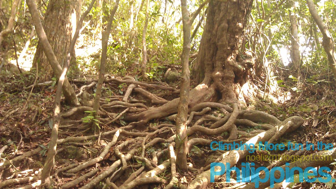
On some parts of the trail, we have to hold on some roots just to do our ascent, like on the part below. Along this trail, there is a very fragrant flowering tree, with a scent like ylang ylang and vanilla combined. It would have been nice to have a similar tree on my backyard!
We have to be careful when holding to branches, as I got stung by an unknown insect, when I held on a root branch. While sitting on a dead tree trunk, a lady companion was bitten by a small scorpion, which luckily has no venom.

After 5:00 pm, we reached the first campsite with tree cover on the western side. A group of 3 wacky guys who call themselves "Adobo Mountaineers" were encamped on that part, so we decided to camp further up, since we don't expect strong winds that night. We were able to pitch our tents before darkness came.

Dinner is composed mainly of heated pre-cooked viands. Since we were not able to buy liquor prior to our trek, we contented ourselves on a leftover tequila from our Mt. Pulag climb. We were blessed with nice weather, no rain that night. Surprisingly, it was not as cold as expected from our exposed campsite. I decided to get inside my sleeping bag, only at about 3:00 am.

We planned to see the sunrise at the summit, but clouds cover the sun from the eastern horizon. That tiny white dot near the center of the photo below is the new moon with crescent shape.

As we prepare for our assault, we saw a hawk and an eagle circling the mountain ridge, while another bird flew just about 1 foot from the head of LH. It was a clear day, and we were excited to climb up to the second peak.

Halfway on our ascent, our tents look like tiny specks on the ridge. The clouds cover the hills and the sea below, hiding the island of Corregidor as well.

But in less than 30 minutes during our ascent, the thick cloud or fog covered most of the ridge. At times, visibility is less than 10 meters. I was only able to reach the clump of the trees near the first peak. I heard a lot of birds near my location, but I think they also stopped moving due to poor visibility.


Almost an hour passed during our ascent and still with thick fog, we decided to go back to our camp for breakfast of coffee, noodles, and bread. We decamped and descended by 8:00 am, reaching the Papaya River before 9:30 am. We cooked our remaining food here for our brunch of corned beef hash and fried danggit. My companions boiled the river water here as their trail water, but I continued to drink mine straight from the source.

During our stay at the river for almost 2 hours, I spotted a small crab trying to hide, submerged in water between the stones.

Before we left the river, a lot of hikers have arrived, taken their lunch, and camped on its banks. Some groups hired porters for Php 600-800 roundtrip fee up to Papaya River, while it will become Php 1,500 if up to Tarak Ridge. When we reached Aling Curding's place, we learned that more than 100 hikers have registered for Tarak climb that Saturday morning.
Here's a view of Tarak Ridge as we got near the jump off point. Note the gathering dark clouds which probably brought rains on the mountain that night.

To cool our bodies, we finished 1-2 bottles each of cold RC Cola on a small variety store along the way. Across the store is Grafane Farm, where we took a bath for Php 20/person, before we went back to the highway for a bus to Razon's in Guagua.

Here's a map of Tarak Ridge (marked "A"). On the north is neighboring Mt. Mariveles, while the tadpole-shaped Corregidor island is on the southeast part.

We were the last customer at Razon's which closes at 7:00 pm. After dinner of pancit palabok and halo-halo, we took another ride back to Manila.
Thanks to our trekmate Gian Burayag of http://www.bossandme.com/ for allowing me to post her "taller" pictures!


pwede makahingi ng IT at expenses nyo, thanks a lot for sharing your hiking experience.
ReplyDeleteHere's our itinerary for Mt. Tarak climb:
ReplyDeleteDAY 1
0700H ETD from Cubao bus terminal
0930H ETA in Alasasin, Mariveles.
Register at Barangay, early lunch
1045H Start trek, took a lot of rest stops
1430H ETA in Papaya River
1450H ETD from Papaya River
1715H Arrived at Campsite, pitch tent, cook
1900H Dinner & socials
DAY 2
0530H Wake up
0600H Start assault to summit
0700H Back to campsite, breakfast, decamp
0800H Start descent
0930H Arrive at Papaya River, prepare lunch
1145H Left Papaya River
1430H Arrive at Grafane Farm, rest & shower
1630H Left Grafane Farm, ride bus to Manila
Expenses Per Head:
Round trip bus fare MLA-Bataan-MLA P 540
Registration fee at Barangay 40
Lunch at Alasasin Carinderia 55
Donation to Aling Curding 10
2 cold RC Cola 16
Shower fee at Grafane farm 20
Palabok & Halo-halo in Razon's 140
TOTAL P 821
Excludes transpo fares from our residence, meals in campsite and bus stops.