I like to keep myself fit, but I don't like to go to the gym, nor do I want to do running despite its popularity now. At the same time, I want to explore new places and experience nature, so trekking in a mountain is the best option for me. Its quite an expensive hobby (transportation, gears, and trek guides), but life is short so we just have to enjoy it, right?
So when I saw a mountain climbing tour schedule at Travel Adventours' website, I booked a tour with them for a Saturday climb, while I'm free from teaching this semestral break. I chose Mt. Maculot in Cuenca, Batangas (See photo above, where the left peak is its rockies).
About a 2-hour drive from Manila passing through SLEX, ACTEX, and STAR tollways exiting in Lipa City, below is the map of the mountain and its proximity from Taal lake and Mt. Makiling.
About a 2-hour drive from Manila passing through SLEX, ACTEX, and STAR tollways exiting in Lipa City, below is the map of the mountain and its proximity from Taal lake and Mt. Makiling.
There were 15 of us on last Saturday's climb, composed of 13 adventourists aided by 2 helpful guides from Travel Adventours. One serves as trail leader (shows the way), while the sweeper ensures that nobody is left behind. Its still dark when our van arrived at the foot of the mountain. By 6:00 am at the trail that leads to the mountain, our sweeper Julian led the stretching exercises to prepare our bodies on the strenuous task ahead.
It does not offer vertical challenge for experienced mountaineers, but its steep slopes will test a beginner climber's endurance. A rim of the previous mega Taal volcano, below are the technical specs of Mt. Maculot, from Pinoy Mountaineer website.
Jump-off point: Brgy. Poblaction, Cuenca, Batangas
LLA: 13°55'15"N; 121°2'30"E; 706 MASL (meters above sea level)
Days required / Hours to Rockies: Half day / 1-2 hours
Specs: Minor climb, Difficulty 2/9, Trail class 1-3
LLA: 13°55'15"N; 121°2'30"E; 706 MASL (meters above sea level)
Days required / Hours to Rockies: Half day / 1-2 hours
Specs: Minor climb, Difficulty 2/9, Trail class 1-3
Guide Ace led the trek starting in a cemented road then to the deep forest. After about 10 minutes of leisure walk, the uphill assault started on inclined grounds ranging from 30 degrees to almost 60 degrees in the rockies. Good thing that most of the path are covered by trees, except on the final 20-minutes of the climb to the campsite, where talahib grass cover the landscape.
One of the markers placed by the Phil. Air Force. This mountain could be their favorite trekking place due to its proximity at their Lipa Air Base.
There are about 8 stations with wooden/bamboo benches along the trail, providing rest stops and photo ops for tired climbers.
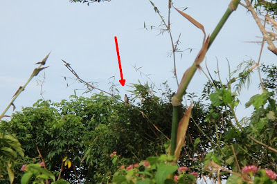
I spotted a tarat bird (brown shrike), a migratory bird from China.
Some more forest views along the way. Its apparent that the Cuenca local government have successfully protected the mountain from "kaingineros" (slash & burn farmers).
A magnificent view along the talahib trail as we approach the campsite. We arrived at the campsite at about 8:50 am, due to the many rest stops and photo shoots.
The campsite with a group of climbers who are cooking breakfast after their overnight stay. See the summit above their photo, which is another 2-hour climb from the campsite with almost non-existent trail due to dense talahib grass and plant growth. Some makeshift camps from local materials were destroyed by recent typhoons. On weekends, there is a store selling beverages on the campsite, and a coconut juice stall on our way down.
The view from campsite to rockies, a downward then upward V-shaped trail. The arrow points to the other group of climbers who camped the night before.
A more challenging part of the downward trail to the rockies. Good thing that everyone made it in one piece on all those rock-hugging paths.
We finally made it to the rockies. I was one of the first 3 persons in our group who arrived at the area. That's me pointed by the arrow in the photo below.
Rewarding views of Cuenca town, the summit, Taal lake and volcano from the rockies. Unfortunately, the fog shrouds the view of Taal and Tagaytay ridge.
The arrows point to 2 coastal communities in the Cuenca portion of the Taal lake.
Here's the view from the rockies to the campsite, as we prepare to get back to it. See the people on the trail as pointed by the arrows.
We started our descent at about 11:30 am, then met 3 more group of climbers on their way up to the mountain. We arrived at the mountaineer store at around 1:00 pm, where we've had a quick bath and lunch. It was a nice adventure, conquering a mountain, and winning new friends at the same time. We exchanged contact details to plan our next mountain to climb.
Credits to worldatlaspedia for the lakeview photo of Mt. Maculot at the top of this post, as well as to my fellow trekkers' facebook pages, where I copied some of the photos above. Until our next climb!


Wah! Naalala ko tuloy yung Mt. Maculot namen. It was really an epic fail. Naligaw kame and in the end bumaba na lang kame kasi gabe na. Hahahah!
ReplyDeleteThanks for visiting the blog. We are going to Mt. Batulao naman tomorrow.
ReplyDeletewow im inspired idol, you are my favorite blogger so far. every time im visiting your blog, you keep on amazing me, from bringing your children to somewhere now on hiking. keep it up!
ReplyDeleteThanks for the compliment. Next post will be about our Saturday hike in Pico de Loro.
ReplyDelete