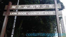
If there is a good hiking spot on a place I visit, I try to include it on my itinerary. Two months ago, I was able to do that in Hong Kong, my first hiking activity outside of the Philippines. It was a perfect day hike of Amah Rock and Lion Rock Hill on my half day schedule.
From the information I gathered from the web, I decided to do a traverse hike of Lion Rock Hill that passes Amah Rock from Tai Wai to Wong Tai Sin areas of the New Territories. Its a northwest to southeast trek that I finished in about 3 hours.
Starting in Tai Wai station of MTR, I passed through Hung Mui Kok road to find the forest trail at the barbecue area.
After hiking for about 20 minutes, I was able to have a glimpse of the famous Amah Rock. To see both the scientific data and mythical legend of the rock, click the second photo of the signage below.
From the cemented walkway with railings where the above signage is located, I took the left trail then turned right on the detour to Amah Rock. There are user-friendly signages with the distances and time to reach your target destination, so getting lost won't be a problem for non-local solo hikers like me.
After about 20 more minutes, I arrived at Amah Rock with the views below.
Continuing the trek, I passed another trail guide. The trail became gradual ascent at this point.
There are lots of monkeys on the trail. According to a story I've read, they were previous pets by locals, then released on the mountain. There are signages along the trail which prohibit feeding the monkeys.
Then I reached the Reunification Pavilion, where I rested for about 5 minutes. Met more local hikers there, mostly on their senior years.
More monkeys on the area moving from one tree to another, sometimes running on the ground.
Then I continued on my hike to the summit.
Where I passed a 1900s granite military marker (middle photo below) after a few steps.
The trail became steeper this time. On the middle photo below which looks like an animal head, you will see why this mountain is named as Lion Rock. The left photo is the distant top view of the lion's head, while the right photo shows warning signs on the way to one of the peaks, as I reached it.
Next are the awesome views from Lion Rock's summit. Even at only 495 MASL, it is one of the toughest yet beautiful trails in HK.
I was lucky to meet 2 Chinese hikers on the summit, who took my photos, despite some language challenges.
When dark clouds and fog threatened the area with rain, I got back to the pavilion then took the left trail that leads to Wong Tai Sin MTR at Shatin area. The trail is paved all throughout, and very slippery when wet. I think this is the shortest trail from summit to civilization.
There are covered rest stations along this most popular trail.
In about 40 minutes, I reached the stairs that lead to a road and a public park. From this point, the Wong Tai Sin MTR station on a mall is less than 15-minute walk.
The trail I took as shown on the map below.
Next time in HK, I plan to hike on Lantau Peak (Fung Wong Shan), the highest publicly accessible summit of Hong Kong!


No comments:
Post a Comment